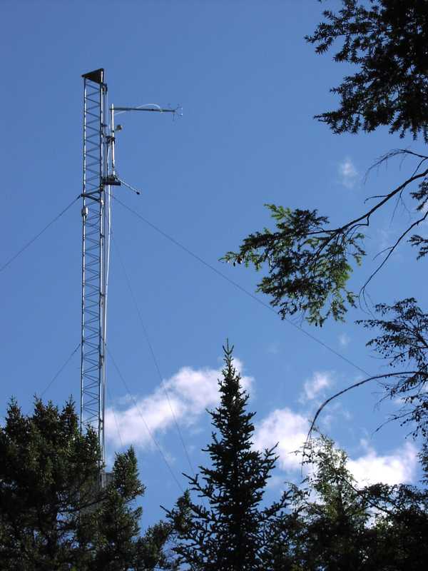
Permanent land sites are set locations containing one or more instruments. These instruments are always kept at this site and continue to collect measurements even after the field campaign is complete. Examples of permanent land sites include permanent towers (such as FLUXNET or ASOS/AWOS), NEXRAD radar sites, AERONET network sites, and airport observation stations.
The Next Generation Weather Radar (NEXRAD) is a network of high-resolution, S-band radars operated by the National Weather Service (NWS), the Federal Aviation Administration (FAA), and the United States Air Force. NEXRAD measures the magnitude of the returned energy to provide reflectivity, velocity, and spectrum width observations, which can be processed to create mosaic maps of precipitation. NEXRAD radars typically operate with a 0.9 degree beamwidth, 0.25-1 km spatial resolution, and 230-460 km maximum range. There are currently over 160 NEXRAD radars operating in the United States and select overseas locations.
The NASA Micro-Pulse Lidar Network (MPLNET) is a global ground-based network of Micro-Pulse Lidar (MPL) systems that has been active since 1999. MPLNET provides continuous measurements of aerosol and cloud vertical structure as well as boundary layer height from the surface up to 30 km. The MPL systems operate at a wavelength range of 523-532 nm and have a vertically-resolved spatial resolution of 30 to 75 m depending on the station. Many of the MPLNET sites are co-located with sites in the NASA Aerosol Robotic Network (AERONET) to help reduce errors in retrievals.
The AErosol RObotic NETwork (AERONET) is a federated network of ground-based remote sensing aerosol sensors established by NASA and the PHOtométrie pour le Traitement Opérationnel de Normalisation Satellitaire (PHOTONS) in 1993. Each AERONET site consists of a CIMEL Electronique sunphotometer that provides measurements of sun irradiance and sky radiances. These measurements can be used to retrieve aerosol properties such as aerosol optical depth and extinction. The sunphotometers operate across nine wavelengths (340, 380, 440, 500, 675, 870, 937, 1020, and 1640 nm) and provide aerosol measurements approximately every 15 min. AERONET sites are located across the world, making it possible to map around 90% of the Earth’s surface.
FLUXNET is a global network of eddy covariance flux towers. Each tower is equipped with gas sensors to continuously measure the fluxes of trace gases such as carbon dioxide, methane, and water vapor between the land surface and the atmosphere. These towers are also equipped with various meteorological sensors to measure air temperature, precipitation, winds, radiation, and soil temperature. Currently, FLUXNET has over 250 flux tower sites across the globe in various vegetation types such as tundra, tropical, forest, and grasslands.
Earth Science > Land Surface > Soils > Soil Temperature
Rain gauges are ground-based instruments that provide in situ measurements of liquid precipitation amounts over a set time. There are multiple types of rain gauges that each collect and record data differently such as the tipping bucket rain gauge and weighing precipitation gauge. Rain gauges can be deployed in various locations due to their relatively small size and easy set-up and are typically colocated with other precipitation instruments such as disdrometers to provide more details about precipitation being collected such as precipitation rate and size distribution.
Earth Science > Spectral/engineering > Infrared Wavelengths > Brightness Temperature
Soil moisture probes are in situ ground-based sensors used to measure soil water content. The most common type of soil moisture probes used for scientific research use dielectric permittivity techniques such as capacitance sensors or time-domain reflectometry sensors. These types of probes measure the charge-storage capacity of the soil to determine the soil moisture content. They typically operate at frequencies around 50 MHz and above to reduce sensitivity to salinity. Soil moisture probes provide continuous measurements and are relatively easy to deploy.
The Advanced Lightning Direction Finder (ALDF) is a ground-based lightning detection sensor. It measures the magnetic field strength and arrival time of lightning radio emissions. These measurements are used to determine the location and time of occurrence of lightning ground strikes. ALDF has a typical maximum range of 600 km. ALDFs are used in different lightning detection networks such as the United States National Lightning Detection Network (NLDN).
Generic-Atmospheric State (Gen-AtmsState) refers to non-specific instruments on a platform used for measurements of atmospheric state parameters. These are typically in situ sensors that measure temperature, pressure, humidity, and wind speed/direction. Types of atmospheric state instruments include thermometers, hygrometers, barometers, and anemometers.
Earth Science > Atmosphere > Atmospheric Water Vapor
Earth Science > Atmosphere > Atmospheric Pressure
Earth Science > Atmosphere > Atmospheric Water Vapor > Water Vapor Indicators > Humidity
Earth Science > Atmosphere > Atmospheric Temperature > Surface Temperature > Air Temperature
This description will be added in a future version.
Earth Science > Spectral/engineering > Radar
The Micropulse Lidar (MPL) is a ground-based lidar system used for cloud detection. It measures lidar backscatter at 532 nm to retrieve cloud properties such as cloud top and base height. It can also be used for the detection of aerosols. MPL has a vertical resolution of 15 m and a maximum range of 18 km. MPL can operate autonomously and typically provides 10-second averaged data.
Earth Science > Spectral/engineering > Lidar > Lidar Depolarization Ratio
The AErosol RObotic NETwork (AERONET) is a federated network of ground-based remote sensing aerosol sensors established by NASA and the PHOtométrie pour le Traitement Opérationnel de Normalisation Satellitaire (PHOTONS) in 1993. Each AERONET site consists of a CIMEL Electronique sunphotometer that provides measurements of sun irradiance and sky radiances. These measurements can be used to retrieve aerosol properties such as aerosol optical depth and extinction. The sunphotometers operate across nine wavelengths (340, 380, 440, 500, 675, 870, 937, 1020, and 1640 nm) and provide aerosol measurements approximately every 15 min. AERONET sites are located across the world, making it possible to map around 90% of the Earth’s surface.
The Lightning Detection and Ranging (LDAR) system is a ground-based lightning network located at the Kennedy Space Center (KSC). It consists of seven very high-frequency (VHF) radio receivers that detect radio pulses produced by lightning. These seven receivers are arranged in a hexagonal pattern about 6 to 10 km apart from the central receiver. The LDAR system operates at the 66 MHz frequency and has a bandwidth of 6 MHz. It has a typical detection range of 100 km and a time resolution of 10 ns. It provides near real-time mapping of lightning in support of Space Shuttle operations.
Earth Science > Atmosphere > Atmospheric Electricity > Electric Field
The Next Generation Weather Radar (NEXRAD) is a network of high-resolution, S-band radars operated by the National Weather Service (NWS), the Federal Aviation Administration (FAA), and the United States Air Force. NEXRAD measures the magnitude of the returned energy to provide reflectivity, velocity, and spectrum width observations, which can be processed to create mosaic maps of precipitation. NEXRAD radars typically operate with a 0.9 degree beamwidth, 0.25-1 km spatial resolution, and 230-460 km maximum range. There are currently over 160 NEXRAD radars operating in the United States and select overseas locations.
The National Lightning Detection Network (NLDN) is a remote, ground-based network operated by Vaisala. It consists of over 100 lightning detection sensors across the United States. These sensors detect the electromagnetic signals given off by lightning to provide information about the location, time, polarity, and amplitude of each lightning stroke. NLDN has a detection efficiency greater than 95% for cloud-ground lightning and has a location accuracy of better than 100 m.
The Cloud‐to‐Ground Lightning Surveillance System (CGLSS) located at the Kennedy Space Center consists of six medium-gain IMPACT Enhanced Sensitivity and Performance (ESP) sensors developed by Vaisala. The CGLSS network processes cloud-to-ground lightning signals by detecting an electromagnetic waveform of the return stroke, transmitting that data to a central processor that estimates stroke intensity and location, and sending the information to users in a real-time setting. Lightning occurrences from the network are used for decision support towards ground and launch activity on the Florida coast.
A Four beam system that uses Yagi antenna with enhanced beam steering capability and contains a Median Filter First Guess (MFFG) algorithm to generate a wind profile from Doppler spectra at each range gate
Generic-Atmospheric State (Gen-AtmsState) refers to non-specific instruments on a platform used for measurements of atmospheric state parameters. These are typically in situ sensors that measure temperature, pressure, humidity, and wind speed/direction. Types of atmospheric state instruments include thermometers, hygrometers, barometers, and anemometers.
Earth Science > Atmosphere > Atmospheric Water Vapor
Earth Science > Atmosphere > Atmospheric Pressure
Earth Science > Atmosphere > Atmospheric Water Vapor > Water Vapor Indicators > Humidity
Earth Science > Atmosphere > Atmospheric Temperature > Surface Temperature > Air Temperature
Generic-Radiometers refer to non-specific radiometers on a platform. These are typically passive microwave radiometers that measure brightness temperature. Radiometers can be used to retrieve temperature and water vapor profiles, soil moisture content, ocean salinity, precipitation and cloud properties, and vegetation.
Earth Science > Spectral/engineering > Microwave > Brightness Temperature
The Pandora Spectrometer System is a ground-based UV-VIS spectrometer used to measure column amounts of trace gases in the atmosphere. It uses total optical absorption spectroscopy for retrievals of ozone, nitrogen dioxide, formaldehyde, and other trace gases. Pandora operates in the 280-525 nm spectral region at a resolution of 0.6 nm. It can make both direct sun and all-sky radiance measurements and has an overall measurement time of 80 seconds. Pandora is a part of a network of identical instruments known as the Pandonia Global Network.
The AErosol RObotic NETwork (AERONET) is a federated network of ground-based remote sensing aerosol sensors established by NASA and the PHOtométrie pour le Traitement Opérationnel de Normalisation Satellitaire (PHOTONS) in 1993. Each AERONET site consists of a CIMEL Electronique sunphotometer that provides measurements of sun irradiance and sky radiances. These measurements can be used to retrieve aerosol properties such as aerosol optical depth and extinction. The sunphotometers operate across nine wavelengths (340, 380, 440, 500, 675, 870, 937, 1020, and 1640 nm) and provide aerosol measurements approximately every 15 min. AERONET sites are located across the world, making it possible to map around 90% of the Earth’s surface.
Generic-Chemistry Related Sensors (Gen-Chemistry) refers to non-specific instruments on a platform used for atmospheric chemistry measurements. These are typically in situ analyzers that measure various chemical compounds such as trace gases, halocarbons, volatile organic compounds, nitrates, aerosols, and other chemical species. Measurements can include mixing ratio, composition, particle size, optical properties, and particle size distribution.
The AErosol RObotic NETwork (AERONET) is a federated network of ground-based remote sensing aerosol sensors established by NASA and the PHOtométrie pour le Traitement Opérationnel de Normalisation Satellitaire (PHOTONS) in 1993. Each AERONET site consists of a CIMEL Electronique sunphotometer that provides measurements of sun irradiance and sky radiances. These measurements can be used to retrieve aerosol properties such as aerosol optical depth and extinction. The sunphotometers operate across nine wavelengths (340, 380, 440, 500, 675, 870, 937, 1020, and 1640 nm) and provide aerosol measurements approximately every 15 min. AERONET sites are located across the world, making it possible to map around 90% of the Earth’s surface.
The Colorado State University Pawnee (CSU-PAWNEE) Doppler Radar was an S-band ground-based radar located in the Pawnee National Grasslands. It was operated by CSU and was often used in conjunction with the CSU-CHILL radar due to the close vicinity of the radars. CSU-PAWNEE operated at the 2.730 GHz frequency and had a typical range resolution of 30 m. CSU-PAWNEE was decommissioned in March 2015.
The Advanced Radar for Meteorological and Operational Research (ARMOR) is a dual-polarization C-band radar operated by the University of Alabama in Huntsville (UAH). It is located at the Huntsville International Airport. ARMOR has a transmit frequency of 5625 MHz and a beam width of 0.9 degrees. ARMOR has a range-gate spacing of 125 m and 250 m, depending on the scan mode of the radar. ARMOR originally served as a WSR-74C radar for the National Weather Service before it was donated to UAH in 2002.
The Lightning Mapping Array (LMA) is a ground-based network of lightning detection sensors. An LMA network consists of very high frequency (VHF) antennas, GPS receivers, and processing systems that measure the location, time, and structure of total lightning. LMA has a horizontal spatial resolution of approximately 6-12 meters, a vertical resolution of approximately 20-30 meters, and a spatial extent of about 200 km from the network center. It has a typical sampling frequency of 10 µs with around 95% accuracy within 100 km of the network. LMA networks exist in several locations including Oklahoma, New Mexico, North Alabama, West Texas, Colorado, and Southern Ontario.
The Next Generation Weather Radar (NEXRAD) is a network of high-resolution, S-band radars operated by the National Weather Service (NWS), the Federal Aviation Administration (FAA), and the United States Air Force. NEXRAD measures the magnitude of the returned energy to provide reflectivity, velocity, and spectrum width observations, which can be processed to create mosaic maps of precipitation. NEXRAD radars typically operate with a 0.9 degree beamwidth, 0.25-1 km spatial resolution, and 230-460 km maximum range. There are currently over 160 NEXRAD radars operating in the United States and select overseas locations.
The Multifunction Phased Array Radar (MPAR) is an airborne S-band radar developed for weather and aircraft surveillance. MPAR has a non-rotating stationary panel, allowing for faster scans compared to standard weather radars. MPAR performs four scan modes simultaneously: Aircraft Track While Scan, Rapid Update Weather Scan, High Fidelity Horizon Weather Scan, and High Fidelity 3D Volume Weather Scan. It operates in the 2.7 to 2.9 GHz frequency range and has a beam width of 1.2 to 2 degrees.
CSU-CHILL is an S- and X-band, dual-polarization scanning radar system operated by Colorado State University (CSU). It is a part of the CSU Research Facility located in Greeley, CO, but it can be transported. Simultaneous operation of the S-band (2.725 GHz) and X-band (9.41 GHz) radars allows for CSU-CHILL to provide high spatial resolution radar measurements, making it useful for hail detection. The S-band radar has a range resolution of 15-150 m and a typical range of 50-300 km. The X-band radar has a range resolution of 15-90 m and a typical range of 75-90 km. CSU-CHILL has a pulse-repetition time (PRT) of 800–2500 ms.
The Lightning Mapping Array (LMA) is a ground-based network of lightning detection sensors. An LMA network consists of very high frequency (VHF) antennas, GPS receivers, and processing systems that measure the location, time, and structure of total lightning. LMA has a horizontal spatial resolution of approximately 6-12 meters, a vertical resolution of approximately 20-30 meters, and a spatial extent of about 200 km from the network center. It has a typical sampling frequency of 10 µs with around 95% accuracy within 100 km of the network. LMA networks exist in several locations including Oklahoma, New Mexico, North Alabama, West Texas, Colorado, and Southern Ontario.
Generic-Atmospheric State (Gen-AtmsState) refers to non-specific instruments on a platform used for measurements of atmospheric state parameters. These are typically in situ sensors that measure temperature, pressure, humidity, and wind speed/direction. Types of atmospheric state instruments include thermometers, hygrometers, barometers, and anemometers.
Earth Science > Atmosphere > Atmospheric Water Vapor
Earth Science > Atmosphere > Atmospheric Pressure
Earth Science > Atmosphere > Atmospheric Water Vapor > Water Vapor Indicators > Humidity
Earth Science > Atmosphere > Atmospheric Temperature > Surface Temperature > Air Temperature
Generic-Radiometers refer to non-specific radiometers on a platform. These are typically passive microwave radiometers that measure brightness temperature. Radiometers can be used to retrieve temperature and water vapor profiles, soil moisture content, ocean salinity, precipitation and cloud properties, and vegetation.
Earth Science > Spectral/engineering > Microwave > Brightness Temperature
The Fourier Transformation Spectrometer (FTS) is a high-resolution airborne and ground-based spectrometer. FTS measures the solar radiance reflected from the surface, which can be used to derive measurements of carbon monoxide (CO), carbon dioxide (CO2), and methane (CH4) in the atmosphere. It has a spatial resolution of around 100m x 1000m and a measurement frequency of 1 Hz for typical research flight conditions.
The Picarro gas concentration analyzer is an in situ airborne or ground-based sensor manufactured by Picarro, Inc. It uses Wavelength-Scanned-Cavity Ring Spectroscopy (WS-CRDS) to measure trace gases such as carbon dioxide, carbon monoxide, methane, and water vapor. For carbon dioxide measurements, the laser within Picarro operates at 1603 nm wavelength and 1651 nm wavelength for methane and water vapor measurements. Picarro has a typical sampling time of 2.5 seconds. Depending on the model, Picarro can also provide measurements of carbon isotopes for gas concentrations.
The Lightning Mapping Array (LMA) is a ground-based network of lightning detection sensors. An LMA network consists of very high frequency (VHF) antennas, GPS receivers, and processing systems that measure the location, time, and structure of total lightning. LMA has a horizontal spatial resolution of approximately 6-12 meters, a vertical resolution of approximately 20-30 meters, and a spatial extent of about 200 km from the network center. It has a typical sampling frequency of 10 µs with around 95% accuracy within 100 km of the network. LMA networks exist in several locations including Oklahoma, New Mexico, North Alabama, West Texas, Colorado, and Southern Ontario.
The Electric Field Change Meter (EFCM) is an airborne in situ electric meter. It is a two-channel (fast and slow) antenna used to measure the changes in the electric field produced by lightning. The fast channel has a sample rate of 10 MHz and is designed to detect the radiative component of the lightning discharge field. The slow channel has a sample rate of 1 MHz and is designed to observe the electrostatic field component. EFCM operates over the 1 Hz-100 kHz frequency range and has a detection limit of 25 km.
Earth Science > Atmosphere > Atmospheric Electricity > Electric Field
Stream gauges are ground-based sensors that provide in situ measurements of the stage or height of rivers and streams. The stream flow or discharge of the river can be derived from the stage measurements. Stream gauges can provide continuous measurements and are useful for monitoring flooding potential and water supply. The United States Geological Survey (USGS) maintains and operates a network of over 10,000 stream gauges across the United States to aid with flood forecasting and water management.
Earth Science > Terrestrial Hydrosphere > Surface Water > Surface Water Processes/measurements > Stage Height
Generic-Atmospheric State (Gen-AtmsState) refers to non-specific instruments on a platform used for measurements of atmospheric state parameters. These are typically in situ sensors that measure temperature, pressure, humidity, and wind speed/direction. Types of atmospheric state instruments include thermometers, hygrometers, barometers, and anemometers.
Earth Science > Atmosphere > Atmospheric Water Vapor
Earth Science > Atmosphere > Atmospheric Pressure
Earth Science > Atmosphere > Atmospheric Water Vapor > Water Vapor Indicators > Humidity
Earth Science > Atmosphere > Atmospheric Temperature > Surface Temperature > Air Temperature
The PAR (Photosynthetically Active Radiation) Sensor reports the Photosynthetic Photon Flux Density (PPFD), which corresponds to micromoles of photons per meter squared per second (μmol m-2 s-1). This is the power of electromagnetic radiation in the spectral range that is used by plants for photosynthesis (400–700 nm). It features a waterproof sensor head and can be used to measure PPFD from sunlight and electric light sources. This sensor is ideal for experiments investigating photosynthesis and primary productivity and can be used in many agricultural and environmental science applications.
Earth Science > >
The Station for Measuring Ecosystem-Atmosphere Relations (SMEAR) is a network of research stations across northern Europe operated by the University of Helsinki. Each station has various in situ instrumentation mounted on flux towers to collect temperature, humidity, wind direction/speed, radiation, and aerosol measurements. Measurements are taken daily at a typical sampling frequency of 1 minute.
Earth Science > Agriculture > Soils > Soil Temperature
Earth Science > Biosphere > Vegetation > Photosynthetically Active Radiation
The Micro Rain Radar (MRR) is a ground-based, vertically pointing, continuous wave K-band (24.23 GHz) radar that measures various parameters of precipitation such as liquid water content and rain rate from near ground level to the lower troposphere. The backscatter received by the MRR’s antenna can measure precipitation size distributions in the range of 0.25 mm to 4.53 mm, as well as calculate the frequency shift of falling precipitation to be used to calculate its velocity. Additional applications of the MRR include locating bright bands, nowcasting precipitation, and capturing chemical transport during precipitation events.
TSI Particle Probes are in situ particle counters and detectors manufactured by TSI Incorporated. They are used to detect aerosol particles and determine concentration and particle counts. TSI Particle Probes are typically combined with particle sizers, which can measure size distribution. TSI Particle Probes can be deployed on aircraft, research vessels, and ground-based platforms.
FLUXNET is a global network of eddy covariance flux towers. Each tower is equipped with gas sensors to continuously measure the fluxes of trace gases such as carbon dioxide, methane, and water vapor between the land surface and the atmosphere. These towers are also equipped with various meteorological sensors to measure air temperature, precipitation, winds, radiation, and soil temperature. Currently, FLUXNET has over 250 flux tower sites across the globe in various vegetation types such as tundra, tropical, forest, and grasslands.
Spectrophotometers are passive photometers that measure the light intensity of the sample solution as a function of the wavelength of the electromagnetic radiation. Spectrophotometers are typically used for ground-based or shipborne observations. They can operate either in the ultraviolet to visible (185-700 nm) spectral range or the infrared (700-15000 nm) range. They are typically used in vegetation studies, air pollution monitoring, and water and soil quality analysis.
The Lightning Mapping Array (LMA) is a ground-based network of lightning detection sensors. An LMA network consists of very high frequency (VHF) antennas, GPS receivers, and processing systems that measure the location, time, and structure of total lightning. LMA has a horizontal spatial resolution of approximately 6-12 meters, a vertical resolution of approximately 20-30 meters, and a spatial extent of about 200 km from the network center. It has a typical sampling frequency of 10 µs with around 95% accuracy within 100 km of the network. LMA networks exist in several locations including Oklahoma, New Mexico, North Alabama, West Texas, Colorado, and Southern Ontario.
The Next Generation Weather Radar (NEXRAD) is a network of high-resolution, S-band radars operated by the National Weather Service (NWS), the Federal Aviation Administration (FAA), and the United States Air Force. NEXRAD measures the magnitude of the returned energy to provide reflectivity, velocity, and spectrum width observations, which can be processed to create mosaic maps of precipitation. NEXRAD radars typically operate with a 0.9 degree beamwidth, 0.25-1 km spatial resolution, and 230-460 km maximum range. There are currently over 160 NEXRAD radars operating in the United States and select overseas locations.
The Colorado State University Pawnee (CSU-PAWNEE) Doppler Radar was an S-band ground-based radar located in the Pawnee National Grasslands. It was operated by CSU and was often used in conjunction with the CSU-CHILL radar due to the close vicinity of the radars. CSU-PAWNEE operated at the 2.730 GHz frequency and had a typical range resolution of 30 m. CSU-PAWNEE was decommissioned in March 2015.
Generic-Atmospheric State (Gen-AtmsState) refers to non-specific instruments on a platform used for measurements of atmospheric state parameters. These are typically in situ sensors that measure temperature, pressure, humidity, and wind speed/direction. Types of atmospheric state instruments include thermometers, hygrometers, barometers, and anemometers.
Earth Science > Atmosphere > Atmospheric Water Vapor
Earth Science > Atmosphere > Atmospheric Pressure
Earth Science > Atmosphere > Atmospheric Water Vapor > Water Vapor Indicators > Humidity
Earth Science > Atmosphere > Atmospheric Temperature > Surface Temperature > Air Temperature
CSU-CHILL is an S- and X-band, dual-polarization scanning radar system operated by Colorado State University (CSU). It is a part of the CSU Research Facility located in Greeley, CO, but it can be transported. Simultaneous operation of the S-band (2.725 GHz) and X-band (9.41 GHz) radars allows for CSU-CHILL to provide high spatial resolution radar measurements, making it useful for hail detection. The S-band radar has a range resolution of 15-150 m and a typical range of 50-300 km. The X-band radar has a range resolution of 15-90 m and a typical range of 75-90 km. CSU-CHILL has a pulse-repetition time (PRT) of 800–2500 ms.
The Next Generation Weather Radar (NEXRAD) is a network of high-resolution, S-band radars operated by the National Weather Service (NWS), the Federal Aviation Administration (FAA), and the United States Air Force. NEXRAD measures the magnitude of the returned energy to provide reflectivity, velocity, and spectrum width observations, which can be processed to create mosaic maps of precipitation. NEXRAD radars typically operate with a 0.9 degree beamwidth, 0.25-1 km spatial resolution, and 230-460 km maximum range. There are currently over 160 NEXRAD radars operating in the United States and select overseas locations.
The NASA Micro-Pulse Lidar Network (MPLNET) is a global ground-based network of Micro-Pulse Lidar (MPL) systems that has been active since 1999. MPLNET provides continuous measurements of aerosol and cloud vertical structure as well as boundary layer height from the surface up to 30 km. The MPL systems operate at a wavelength range of 523-532 nm and have a vertically-resolved spatial resolution of 30 to 75 m depending on the station. Many of the MPLNET sites are co-located with sites in the NASA Aerosol Robotic Network (AERONET) to help reduce errors in retrievals.
The Pandora Spectrometer System is a ground-based UV-VIS spectrometer used to measure column amounts of trace gases in the atmosphere. It uses total optical absorption spectroscopy for retrievals of ozone, nitrogen dioxide, formaldehyde, and other trace gases. Pandora operates in the 280-525 nm spectral region at a resolution of 0.6 nm. It can make both direct sun and all-sky radiance measurements and has an overall measurement time of 80 seconds. Pandora is a part of a network of identical instruments known as the Pandonia Global Network.
The AErosol RObotic NETwork (AERONET) is a federated network of ground-based remote sensing aerosol sensors established by NASA and the PHOtométrie pour le Traitement Opérationnel de Normalisation Satellitaire (PHOTONS) in 1993. Each AERONET site consists of a CIMEL Electronique sunphotometer that provides measurements of sun irradiance and sky radiances. These measurements can be used to retrieve aerosol properties such as aerosol optical depth and extinction. The sunphotometers operate across nine wavelengths (340, 380, 440, 500, 675, 870, 937, 1020, and 1640 nm) and provide aerosol measurements approximately every 15 min. AERONET sites are located across the world, making it possible to map around 90% of the Earth’s surface.
Generic-Chemistry Related Sensors (Gen-Chemistry) refers to non-specific instruments on a platform used for atmospheric chemistry measurements. These are typically in situ analyzers that measure various chemical compounds such as trace gases, halocarbons, volatile organic compounds, nitrates, aerosols, and other chemical species. Measurements can include mixing ratio, composition, particle size, optical properties, and particle size distribution.
Ceilometers are ground-based, remote-sensing sensors that provide measurements of cloud ceilings and vertical visibility. They use either a laser beam or another light source to detect backscatter of clouds, precipitation, and aerosols. Ceilometers can provide detailed and accurate measurements in all types of weather conditions and have low operating costs. Ceilometers are typically used in boundary layer and cloud research applications.
Generic-Atmospheric State (Gen-AtmsState) refers to non-specific instruments on a platform used for measurements of atmospheric state parameters. These are typically in situ sensors that measure temperature, pressure, humidity, and wind speed/direction. Types of atmospheric state instruments include thermometers, hygrometers, barometers, and anemometers.
Earth Science > Atmosphere > Atmospheric Water Vapor
Earth Science > Atmosphere > Atmospheric Pressure
Earth Science > Atmosphere > Atmospheric Water Vapor > Water Vapor Indicators > Humidity
Earth Science > Atmosphere > Atmospheric Temperature > Surface Temperature > Air Temperature
The NASA Micro-Pulse Lidar Network (MPLNET) is a global ground-based network of Micro-Pulse Lidar (MPL) systems that has been active since 1999. MPLNET provides continuous measurements of aerosol and cloud vertical structure as well as boundary layer height from the surface up to 30 km. The MPL systems operate at a wavelength range of 523-532 nm and have a vertically-resolved spatial resolution of 30 to 75 m depending on the station. Many of the MPLNET sites are co-located with sites in the NASA Aerosol Robotic Network (AERONET) to help reduce errors in retrievals.
The Pandora Spectrometer System is a ground-based UV-VIS spectrometer used to measure column amounts of trace gases in the atmosphere. It uses total optical absorption spectroscopy for retrievals of ozone, nitrogen dioxide, formaldehyde, and other trace gases. Pandora operates in the 280-525 nm spectral region at a resolution of 0.6 nm. It can make both direct sun and all-sky radiance measurements and has an overall measurement time of 80 seconds. Pandora is a part of a network of identical instruments known as the Pandonia Global Network.
The AErosol RObotic NETwork (AERONET) is a federated network of ground-based remote sensing aerosol sensors established by NASA and the PHOtométrie pour le Traitement Opérationnel de Normalisation Satellitaire (PHOTONS) in 1993. Each AERONET site consists of a CIMEL Electronique sunphotometer that provides measurements of sun irradiance and sky radiances. These measurements can be used to retrieve aerosol properties such as aerosol optical depth and extinction. The sunphotometers operate across nine wavelengths (340, 380, 440, 500, 675, 870, 937, 1020, and 1640 nm) and provide aerosol measurements approximately every 15 min. AERONET sites are located across the world, making it possible to map around 90% of the Earth’s surface.
Generic-Atmospheric State (Gen-AtmsState) refers to non-specific instruments on a platform used for measurements of atmospheric state parameters. These are typically in situ sensors that measure temperature, pressure, humidity, and wind speed/direction. Types of atmospheric state instruments include thermometers, hygrometers, barometers, and anemometers.
Earth Science > Atmosphere > Atmospheric Water Vapor
Earth Science > Atmosphere > Atmospheric Pressure
Earth Science > Atmosphere > Atmospheric Water Vapor > Water Vapor Indicators > Humidity
Earth Science > Atmosphere > Atmospheric Temperature > Surface Temperature > Air Temperature
Generic-Chemistry Related Sensors (Gen-Chemistry) refers to non-specific instruments on a platform used for atmospheric chemistry measurements. These are typically in situ analyzers that measure various chemical compounds such as trace gases, halocarbons, volatile organic compounds, nitrates, aerosols, and other chemical species. Measurements can include mixing ratio, composition, particle size, optical properties, and particle size distribution.
The NASA Micro-Pulse Lidar Network (MPLNET) is a global ground-based network of Micro-Pulse Lidar (MPL) systems that has been active since 1999. MPLNET provides continuous measurements of aerosol and cloud vertical structure as well as boundary layer height from the surface up to 30 km. The MPL systems operate at a wavelength range of 523-532 nm and have a vertically-resolved spatial resolution of 30 to 75 m depending on the station. Many of the MPLNET sites are co-located with sites in the NASA Aerosol Robotic Network (AERONET) to help reduce errors in retrievals.
The Pandora Spectrometer System is a ground-based UV-VIS spectrometer used to measure column amounts of trace gases in the atmosphere. It uses total optical absorption spectroscopy for retrievals of ozone, nitrogen dioxide, formaldehyde, and other trace gases. Pandora operates in the 280-525 nm spectral region at a resolution of 0.6 nm. It can make both direct sun and all-sky radiance measurements and has an overall measurement time of 80 seconds. Pandora is a part of a network of identical instruments known as the Pandonia Global Network.
The AErosol RObotic NETwork (AERONET) is a federated network of ground-based remote sensing aerosol sensors established by NASA and the PHOtométrie pour le Traitement Opérationnel de Normalisation Satellitaire (PHOTONS) in 1993. Each AERONET site consists of a CIMEL Electronique sunphotometer that provides measurements of sun irradiance and sky radiances. These measurements can be used to retrieve aerosol properties such as aerosol optical depth and extinction. The sunphotometers operate across nine wavelengths (340, 380, 440, 500, 675, 870, 937, 1020, and 1640 nm) and provide aerosol measurements approximately every 15 min. AERONET sites are located across the world, making it possible to map around 90% of the Earth’s surface.
Ceilometers are ground-based, remote-sensing sensors that provide measurements of cloud ceilings and vertical visibility. They use either a laser beam or another light source to detect backscatter of clouds, precipitation, and aerosols. Ceilometers can provide detailed and accurate measurements in all types of weather conditions and have low operating costs. Ceilometers are typically used in boundary layer and cloud research applications.
Generic-Atmospheric State (Gen-AtmsState) refers to non-specific instruments on a platform used for measurements of atmospheric state parameters. These are typically in situ sensors that measure temperature, pressure, humidity, and wind speed/direction. Types of atmospheric state instruments include thermometers, hygrometers, barometers, and anemometers.
Earth Science > Atmosphere > Atmospheric Water Vapor
Earth Science > Atmosphere > Atmospheric Pressure
Earth Science > Atmosphere > Atmospheric Water Vapor > Water Vapor Indicators > Humidity
Earth Science > Atmosphere > Atmospheric Temperature > Surface Temperature > Air Temperature
Generic-Chemistry Related Sensors (Gen-Chemistry) refers to non-specific instruments on a platform used for atmospheric chemistry measurements. These are typically in situ analyzers that measure various chemical compounds such as trace gases, halocarbons, volatile organic compounds, nitrates, aerosols, and other chemical species. Measurements can include mixing ratio, composition, particle size, optical properties, and particle size distribution.
The NASA Goddard Tropospheric Ozone Lidar (TROPOZ) is a mobile, ground-based lidar that is part of the Tropospheric Ozone Lidar Network (TOLNet). It uses the differential absorption lidar (DIAL) technique to measure ozone at 289 nm and 299 nm. TROPOZ has a range resolution of 15 m, a repetition rate of 50 Hz, and can generate ozone profiles from 0.35 to 16 km above ground level.
Earth Science > Atmosphere > Air Quality > Tropospheric Ozone
The NASA Micro-Pulse Lidar Network (MPLNET) is a global ground-based network of Micro-Pulse Lidar (MPL) systems that has been active since 1999. MPLNET provides continuous measurements of aerosol and cloud vertical structure as well as boundary layer height from the surface up to 30 km. The MPL systems operate at a wavelength range of 523-532 nm and have a vertically-resolved spatial resolution of 30 to 75 m depending on the station. Many of the MPLNET sites are co-located with sites in the NASA Aerosol Robotic Network (AERONET) to help reduce errors in retrievals.
The AErosol RObotic NETwork (AERONET) is a federated network of ground-based remote sensing aerosol sensors established by NASA and the PHOtométrie pour le Traitement Opérationnel de Normalisation Satellitaire (PHOTONS) in 1993. Each AERONET site consists of a CIMEL Electronique sunphotometer that provides measurements of sun irradiance and sky radiances. These measurements can be used to retrieve aerosol properties such as aerosol optical depth and extinction. The sunphotometers operate across nine wavelengths (340, 380, 440, 500, 675, 870, 937, 1020, and 1640 nm) and provide aerosol measurements approximately every 15 min. AERONET sites are located across the world, making it possible to map around 90% of the Earth’s surface.
The Next Generation Weather Radar (NEXRAD) is a network of high-resolution, S-band radars operated by the National Weather Service (NWS), the Federal Aviation Administration (FAA), and the United States Air Force. NEXRAD measures the magnitude of the returned energy to provide reflectivity, velocity, and spectrum width observations, which can be processed to create mosaic maps of precipitation. NEXRAD radars typically operate with a 0.9 degree beamwidth, 0.25-1 km spatial resolution, and 230-460 km maximum range. There are currently over 160 NEXRAD radars operating in the United States and select overseas locations.
The NASA Micro-Pulse Lidar Network (MPLNET) is a global ground-based network of Micro-Pulse Lidar (MPL) systems that has been active since 1999. MPLNET provides continuous measurements of aerosol and cloud vertical structure as well as boundary layer height from the surface up to 30 km. The MPL systems operate at a wavelength range of 523-532 nm and have a vertically-resolved spatial resolution of 30 to 75 m depending on the station. Many of the MPLNET sites are co-located with sites in the NASA Aerosol Robotic Network (AERONET) to help reduce errors in retrievals.
Ceilometers are ground-based, remote-sensing sensors that provide measurements of cloud ceilings and vertical visibility. They use either a laser beam or another light source to detect backscatter of clouds, precipitation, and aerosols. Ceilometers can provide detailed and accurate measurements in all types of weather conditions and have low operating costs. Ceilometers are typically used in boundary layer and cloud research applications.
Generic-Atmospheric State (Gen-AtmsState) refers to non-specific instruments on a platform used for measurements of atmospheric state parameters. These are typically in situ sensors that measure temperature, pressure, humidity, and wind speed/direction. Types of atmospheric state instruments include thermometers, hygrometers, barometers, and anemometers.
Earth Science > Atmosphere > Atmospheric Water Vapor
Earth Science > Atmosphere > Atmospheric Pressure
Earth Science > Atmosphere > Atmospheric Water Vapor > Water Vapor Indicators > Humidity
Earth Science > Atmosphere > Atmospheric Temperature > Surface Temperature > Air Temperature
The Ultra-High Frequency (UHF) Wind Profiler is a ground-based Doppler radar. It measures electromagnetic signals to detect wind speed and direction. UHF Wind Profilers operate at the 300-1000 MHz frequency range. Due to operating at a high frequency, they allow for high-resolution wind measurements within the boundary layer.
The Millimeter-Wavelength Cloud Radar (MMCR) is a ground-based radar developed by the NOAA Environmental Technology Laboratory (ETL) for the Department of Energy (DoE) Atmospheric Radiation Measurement (ARM) sites. MMCR provides long-term observations of radar reflectivity, Doppler velocity, spectrum width, and other radar parameters for precipitating and nonprecipitating clouds up to 20 km above ground level (AGL). It is a vertically pointing, single-polarization radar system that operates at around 35 GHz. MMCR has a beamwidth of 0.2 degrees and typical vertical resolutions of 45 and 90 meters.
The microwave radiometers (MWRs) are ground-based radiometers manufactured by Radiometrics Corporation and operated by the Atmospheric Radiation Measurement (ARM) Research Facility. MWR measures brightness temperature at 23.8 and 31.4 GHz to derive column-integrated amounts of water vapor and liquid water in the atmosphere. MWR has a field of view (FOV) from about 5.9 to 4.5 degrees depending on the channel and has a typical time resolution of 20 s for sky-view observations.
Earth Science > Atmosphere > Atmospheric Water Vapor > Water Vapor Indicators > Water Vapor
Earth Science > Spectral/engineering > Microwave > Brightness Temperature
Earth Science > Atmosphere > Atmospheric Water Vapor
The Atmospheric Emitted Radiance Interferometer (AERI) is a ground-based passive interferometer developed by the University of Wisconsin Space Science and Engineering Center (UW-SSEC) for the Department of Energy (DoE) Atmospheric Radiation Measurement (ARM) Program. It uses Fourier transform spectroscopy to measure downwelling thermal infrared emissions from the atmosphere. These measurements can be used to provide profile measurements of atmospheric temperature and water vapor and detect trace gases. AERI operates across the 3.3-19 μm spectral range and up to 25 μm for the extended range version of the instrument. It has an optimal vertical resolution of 100 meters and completes a full sky scan about every 20 seconds.
Generic-Radiometers refer to non-specific radiometers on a platform. These are typically passive microwave radiometers that measure brightness temperature. Radiometers can be used to retrieve temperature and water vapor profiles, soil moisture content, ocean salinity, precipitation and cloud properties, and vegetation.
Earth Science > Spectral/engineering > Microwave > Brightness Temperature
The Micropulse Lidar (MPL) is a ground-based lidar system used for cloud detection. It measures lidar backscatter at 532 nm to retrieve cloud properties such as cloud top and base height. It can also be used for the detection of aerosols. MPL has a vertical resolution of 15 m and a maximum range of 18 km. MPL can operate autonomously and typically provides 10-second averaged data.
Earth Science > Spectral/engineering > Lidar > Lidar Depolarization Ratio
Sunphotometers are passive optical sensors that measure the amount of sunlight. They are pointed directly at the sun to measure direct sunlight and not sunlight scatter from aerosols. These measurements can be used to determine the aerosol optical depth by following Beer’s Law. Sunphotometers have been deployed on aircraft, research vessels, and field sites for aerosol research and monitoring.
The Multifilter Rotating Shadowband Radiometer (MFRSR) is a ground-based passive radiometer used to measure the global and diffuse components of solar irradiance. It measures solar irradiance across six narrowband channels and one broadband channel. The nominal wavelengths of the narrowband channels are 415, 500, 615, 673, 870, and 940 nm. MFRSR has a typical sampling interval of 20 seconds and takes measurements at four different shadowband positions: nadir, first side-band, sun-blocked, and second side-band. MFRSR is deployed across several of the Department of Energy’s Atmospheric Radiation Measurement (ARM) User Facility sites.
The Next Generation Weather Radar (NEXRAD) is a network of high-resolution, S-band radars operated by the National Weather Service (NWS), the Federal Aviation Administration (FAA), and the United States Air Force. NEXRAD measures the magnitude of the returned energy to provide reflectivity, velocity, and spectrum width observations, which can be processed to create mosaic maps of precipitation. NEXRAD radars typically operate with a 0.9 degree beamwidth, 0.25-1 km spatial resolution, and 230-460 km maximum range. There are currently over 160 NEXRAD radars operating in the United States and select overseas locations.
Eddy Covariance Flux Towers are in situ micrometeorological surface towers. They are equipped with gas sensors to continuously measure the trace gas fluxes between the land surface and the atmosphere. Eddy Covariance Towers are typically used to measure fluxes for carbon dioxide (CO2), methane (CH4), and water vapor (H2O). These towers are also equipped with various meteorological sensors to measure air temperature, precipitation, winds, radiation, and soil temperature.
The AErosol RObotic NETwork (AERONET) is a federated network of ground-based remote sensing aerosol sensors established by NASA and the PHOtométrie pour le Traitement Opérationnel de Normalisation Satellitaire (PHOTONS) in 1993. Each AERONET site consists of a CIMEL Electronique sunphotometer that provides measurements of sun irradiance and sky radiances. These measurements can be used to retrieve aerosol properties such as aerosol optical depth and extinction. The sunphotometers operate across nine wavelengths (340, 380, 440, 500, 675, 870, 937, 1020, and 1640 nm) and provide aerosol measurements approximately every 15 min. AERONET sites are located across the world, making it possible to map around 90% of the Earth’s surface.
The NASA Micro-Pulse Lidar Network (MPLNET) is a global ground-based network of Micro-Pulse Lidar (MPL) systems that has been active since 1999. MPLNET provides continuous measurements of aerosol and cloud vertical structure as well as boundary layer height from the surface up to 30 km. The MPL systems operate at a wavelength range of 523-532 nm and have a vertically-resolved spatial resolution of 30 to 75 m depending on the station. Many of the MPLNET sites are co-located with sites in the NASA Aerosol Robotic Network (AERONET) to help reduce errors in retrievals.
The Arrival Time Difference Network (ATDnet) is a ground-based lightning detection network operated by the United Kingdom Meteorological Office. It consists of several sensors across Europe that detect lightning in Europe, northern Africa, and the northern Atlantic Ocean. It uses very-low-frequency (VLF) sensors to detect the electromagnetic waves or sferics generated by lightning strikes to determine the number and location of lightning strikes. These sensors operate at a central frequency of 13.733 kHz and have a time resolution of 1 ns. ATDnet has a location accuracy of 1-3 km.
The ZEUS Long-Range Lightning Detection Network is a ground-based network of ZEUS lightning detection systems across Europe, Africa, and Brazil. ZEUS detects the sferics emitted by a cloud-to-ground lightning strike in the very low frequency (VLF) spectrum (7-15 kHz). The lightning location and time are determined by using the arrival time difference (ATD) technique. ZEUS can measure 70 sferics per second and has a spatial accuracy of 10-20 km within the network periphery.
FLUXNET is a global network of eddy covariance flux towers. Each tower is equipped with gas sensors to continuously measure the fluxes of trace gases such as carbon dioxide, methane, and water vapor between the land surface and the atmosphere. These towers are also equipped with various meteorological sensors to measure air temperature, precipitation, winds, radiation, and soil temperature. Currently, FLUXNET has over 250 flux tower sites across the globe in various vegetation types such as tundra, tropical, forest, and grasslands.
Eddy Covariance Flux Towers are in situ micrometeorological surface towers. They are equipped with gas sensors to continuously measure the trace gas fluxes between the land surface and the atmosphere. Eddy Covariance Towers are typically used to measure fluxes for carbon dioxide (CO2), methane (CH4), and water vapor (H2O). These towers are also equipped with various meteorological sensors to measure air temperature, precipitation, winds, radiation, and soil temperature.
The Pandora Spectrometer System is a ground-based UV-VIS spectrometer used to measure column amounts of trace gases in the atmosphere. It uses total optical absorption spectroscopy for retrievals of ozone, nitrogen dioxide, formaldehyde, and other trace gases. Pandora operates in the 280-525 nm spectral region at a resolution of 0.6 nm. It can make both direct sun and all-sky radiance measurements and has an overall measurement time of 80 seconds. Pandora is a part of a network of identical instruments known as the Pandonia Global Network.
The Next Generation Weather Radar (NEXRAD) is a network of high-resolution, S-band radars operated by the National Weather Service (NWS), the Federal Aviation Administration (FAA), and the United States Air Force. NEXRAD measures the magnitude of the returned energy to provide reflectivity, velocity, and spectrum width observations, which can be processed to create mosaic maps of precipitation. NEXRAD radars typically operate with a 0.9 degree beamwidth, 0.25-1 km spatial resolution, and 230-460 km maximum range. There are currently over 160 NEXRAD radars operating in the United States and select overseas locations.
Earth Science > Atmosphere > Atmospheric Temperature
Earth Science > Atmosphere > Atmospheric Winds
The Next Generation Weather Radar (NEXRAD) is a network of high-resolution, S-band radars operated by the National Weather Service (NWS), the Federal Aviation Administration (FAA), and the United States Air Force. NEXRAD measures the magnitude of the returned energy to provide reflectivity, velocity, and spectrum width observations, which can be processed to create mosaic maps of precipitation. NEXRAD radars typically operate with a 0.9 degree beamwidth, 0.25-1 km spatial resolution, and 230-460 km maximum range. There are currently over 160 NEXRAD radars operating in the United States and select overseas locations.
Generic-Atmospheric State (Gen-AtmsState) refers to non-specific instruments on a platform used for measurements of atmospheric state parameters. These are typically in situ sensors that measure temperature, pressure, humidity, and wind speed/direction. Types of atmospheric state instruments include thermometers, hygrometers, barometers, and anemometers.
Earth Science > Atmosphere > Atmospheric Water Vapor
Earth Science > Atmosphere > Atmospheric Pressure
Earth Science > Atmosphere > Atmospheric Water Vapor > Water Vapor Indicators > Humidity
Earth Science > Atmosphere > Atmospheric Temperature > Surface Temperature > Air Temperature
The LI-COR Plant Canopy Analyzer is an in situ analyzer manufactured by LI-COR for leaf area index (LAI) measurements. It measures diffuse sky radiation that passes through the canopy across five zenith angels to determine LAI and other canopy characteristics. It can be used for most sky conditions and canopy types, such as row crops, grasslands, isolated trees, and forests. The optical sensor within the Plant Canopy Analyzer has a wavelength range of 320-490 nm. It has a field of view of 148 degrees and an operating temperature range of -20 to 50 degrees Celsius.
Earth Science > Biosphere > Vegetation > Vegetation Index > Leaf Area Index (lai)
Earth Science > Biosphere > Vegetation > Leaf Characteristics > Leaf Area Index (lai)
Generic-Atmospheric State (Gen-AtmsState) refers to non-specific instruments on a platform used for measurements of atmospheric state parameters. These are typically in situ sensors that measure temperature, pressure, humidity, and wind speed/direction. Types of atmospheric state instruments include thermometers, hygrometers, barometers, and anemometers.
Earth Science > Atmosphere > Atmospheric Water Vapor
Earth Science > Atmosphere > Atmospheric Pressure
Earth Science > Atmosphere > Atmospheric Water Vapor > Water Vapor Indicators > Humidity
Earth Science > Atmosphere > Atmospheric Temperature > Surface Temperature > Air Temperature
FLUXNET is a global network of eddy covariance flux towers. Each tower is equipped with gas sensors to continuously measure the fluxes of trace gases such as carbon dioxide, methane, and water vapor between the land surface and the atmosphere. These towers are also equipped with various meteorological sensors to measure air temperature, precipitation, winds, radiation, and soil temperature. Currently, FLUXNET has over 250 flux tower sites across the globe in various vegetation types such as tundra, tropical, forest, and grasslands.
The Millimeter-Wavelength Cloud Radar (MMCR) is a ground-based radar developed by the NOAA Environmental Technology Laboratory (ETL) for the Department of Energy (DoE) Atmospheric Radiation Measurement (ARM) sites. MMCR provides long-term observations of radar reflectivity, Doppler velocity, spectrum width, and other radar parameters for precipitating and nonprecipitating clouds up to 20 km above ground level (AGL). It is a vertically pointing, single-polarization radar system that operates at around 35 GHz. MMCR has a beamwidth of 0.2 degrees and typical vertical resolutions of 45 and 90 meters.
The Atmospheric Emitted Radiance Interferometer (AERI) is a ground-based passive interferometer developed by the University of Wisconsin Space Science and Engineering Center (UW-SSEC) for the Department of Energy (DoE) Atmospheric Radiation Measurement (ARM) Program. It uses Fourier transform spectroscopy to measure downwelling thermal infrared emissions from the atmosphere. These measurements can be used to provide profile measurements of atmospheric temperature and water vapor and detect trace gases. AERI operates across the 3.3-19 μm spectral range and up to 25 μm for the extended range version of the instrument. It has an optimal vertical resolution of 100 meters and completes a full sky scan about every 20 seconds.
The Total Sky Imager (TSI) is a ground-based, optical instrument that is manufactured by Yankee Environmental Systems (YES), Inc. TSI can provide full-color, hemispheric images of the sky during the day by using a charge-coupled device (CCD) imager. It also can provide measurements of fractional sky cover and sun obscuration by cloud. TSI can be mounted on mobile platforms such as trailers and research vehicles, allowing it to collect cloud cover measurements in various locations during a field investigation.
The Micropulse Lidar (MPL) is a ground-based lidar system used for cloud detection. It measures lidar backscatter at 532 nm to retrieve cloud properties such as cloud top and base height. It can also be used for the detection of aerosols. MPL has a vertical resolution of 15 m and a maximum range of 18 km. MPL can operate autonomously and typically provides 10-second averaged data.
The Differential Absorption Lidar (DIAL) is an airborne lidar system designed at NASA’s Langley Research Center (LaRC). It uses four lasers to detect lidar backscatter to provide profile measurements of ozone and aerosols in the atmosphere. DIAL operates in the ultraviolet (289-300 nm) for ozone measurements and operates in the visible (572-600 nm) and infrared (1064 nm) for aerosols. It has a horizontal spatial resolution of approximately 15 km and has a measurement accuracy of 5 ppbv.
Earth Science > Spectral/engineering > Lidar > Lidar Depolarization Ratio
The Airborne Raman Ozone, Temperature, and Aerosol Lidar (AROTAL) is an airborne lidar system operated by Goddard Space Flight Center (GSFC). It detects lidar backscatter to provide vertical profiles of ozone, temperature, and aerosols. It operates across four transmitted wavelengths: 308, 355, 532, and 1064 nm. It also collects Raman scattering at 332 nm and 387 nm. AROTAL has a horizontal resolution of about 4 to 7 km and a vertical resolution of 0.5 to 1.5 km.
The Pandora Spectrometer System is a ground-based UV-VIS spectrometer used to measure column amounts of trace gases in the atmosphere. It uses total optical absorption spectroscopy for retrievals of ozone, nitrogen dioxide, formaldehyde, and other trace gases. Pandora operates in the 280-525 nm spectral region at a resolution of 0.6 nm. It can make both direct sun and all-sky radiance measurements and has an overall measurement time of 80 seconds. Pandora is a part of a network of identical instruments known as the Pandonia Global Network.
The AErosol RObotic NETwork (AERONET) is a federated network of ground-based remote sensing aerosol sensors established by NASA and the PHOtométrie pour le Traitement Opérationnel de Normalisation Satellitaire (PHOTONS) in 1993. Each AERONET site consists of a CIMEL Electronique sunphotometer that provides measurements of sun irradiance and sky radiances. These measurements can be used to retrieve aerosol properties such as aerosol optical depth and extinction. The sunphotometers operate across nine wavelengths (340, 380, 440, 500, 675, 870, 937, 1020, and 1640 nm) and provide aerosol measurements approximately every 15 min. AERONET sites are located across the world, making it possible to map around 90% of the Earth’s surface.
The National Lightning Detection Network (NLDN) is a remote, ground-based network operated by Vaisala. It consists of over 100 lightning detection sensors across the United States. These sensors detect the electromagnetic signals given off by lightning to provide information about the location, time, polarity, and amplitude of each lightning stroke. NLDN has a detection efficiency greater than 95% for cloud-ground lightning and has a location accuracy of better than 100 m.
The Differential Absorption Lidar (DIAL) is an airborne lidar system designed at NASA’s Langley Research Center (LaRC). It uses four lasers to detect lidar backscatter to provide profile measurements of ozone and aerosols in the atmosphere. DIAL operates in the ultraviolet (289-300 nm) for ozone measurements and operates in the visible (572-600 nm) and infrared (1064 nm) for aerosols. It has a horizontal spatial resolution of approximately 15 km and has a measurement accuracy of 5 ppbv.
Sunphotometers are passive optical sensors that measure the amount of sunlight. They are pointed directly at the sun to measure direct sunlight and not sunlight scatter from aerosols. These measurements can be used to determine the aerosol optical depth by following Beer’s Law. Sunphotometers have been deployed on aircraft, research vessels, and field sites for aerosol research and monitoring.
Generic-Chemistry Related Sensors (Gen-Chemistry) refers to non-specific instruments on a platform used for atmospheric chemistry measurements. These are typically in situ analyzers that measure various chemical compounds such as trace gases, halocarbons, volatile organic compounds, nitrates, aerosols, and other chemical species. Measurements can include mixing ratio, composition, particle size, optical properties, and particle size distribution.
Generic-Atmospheric State (Gen-AtmsState) refers to non-specific instruments on a platform used for measurements of atmospheric state parameters. These are typically in situ sensors that measure temperature, pressure, humidity, and wind speed/direction. Types of atmospheric state instruments include thermometers, hygrometers, barometers, and anemometers.
Earth Science > Atmosphere > Atmospheric Water Vapor
Earth Science > Atmosphere > Atmospheric Pressure
Earth Science > Atmosphere > Atmospheric Water Vapor > Water Vapor Indicators > Humidity
Earth Science > Atmosphere > Atmospheric Temperature > Surface Temperature > Air Temperature
Generic-Radiometers refer to non-specific radiometers on a platform. These are typically passive microwave radiometers that measure brightness temperature. Radiometers can be used to retrieve temperature and water vapor profiles, soil moisture content, ocean salinity, precipitation and cloud properties, and vegetation.
Earth Science > Spectral/engineering > Microwave > Brightness Temperature
Digital cameras are used to provide imagery for research applications. Cameras are used on aircraft to collect aerial imagery for mapping and surveying, environmental monitoring, cloud observations, agriculture, geological studies, and other Earth science applications. They are also used at field sites to capture visual observations to monitor changes in land cover, vegetation, clouds, air quality, glaciers, and other phenomena.
The microwave radiometers (MWRs) are ground-based radiometers manufactured by Radiometrics Corporation and operated by the Atmospheric Radiation Measurement (ARM) Research Facility. MWR measures brightness temperature at 23.8 and 31.4 GHz to derive column-integrated amounts of water vapor and liquid water in the atmosphere. MWR has a field of view (FOV) from about 5.9 to 4.5 degrees depending on the channel and has a typical time resolution of 20 s for sky-view observations.
Earth Science > Atmosphere > Atmospheric Water Vapor > Water Vapor Indicators > Water Vapor
Earth Science > Spectral/engineering > Microwave > Brightness Temperature
Earth Science > Atmosphere > Atmospheric Water Vapor
This data will be added in future versions
Earth Science > >
The Atmospheric Emitted Radiance Interferometer (AERI) is a ground-based passive interferometer developed by the University of Wisconsin Space Science and Engineering Center (UW-SSEC) for the Department of Energy (DoE) Atmospheric Radiation Measurement (ARM) Program. It uses Fourier transform spectroscopy to measure downwelling thermal infrared emissions from the atmosphere. These measurements can be used to provide profile measurements of atmospheric temperature and water vapor and detect trace gases. AERI operates across the 3.3-19 μm spectral range and up to 25 μm for the extended range version of the instrument. It has an optimal vertical resolution of 100 meters and completes a full sky scan about every 20 seconds.
The Radiation Measurement System (RAMS) is an airborne passive radiometer that measures broadband solar irradiance. RAMS consists of two radiometers: the Total Solar Broadband Radiometer (TSBR) and the Fractional Solar Broadband Radiometer (FSBR). The TSBR operates in the 0.224 to 3.91 μm range while the FSBR operates between 0.68 to 3.3 μm. It has a response time of about 60 msec and can provide measurements about every 5 m for aircraft speeds around 75 m/s. RAMS is typically used for airborne operations, but it can be used to collect ground-based measurements as well.
Earth Science > Atmosphere > Atmospheric Radiation > Solar Irradiance
W-band radars are highly sensitive radars used for atmospheric research. They operate around the 94-95 GHz frequency band, allowing for the detection of small water droplets. W-band radars are used for cloud and precipitation studies since they can provide more detailed observations than typical weather radars. They can be deployed on research vessels, aircraft, and mobile ground-based platforms.
The Solar Spectral Flux Radiometer (SSFR) is an airborne radiometer developed by the Ames Atmospheric Radiation Group. It provides remotely sensed measurements of solar spectral irradiance in the troposphere. SSFR operates across the 300-2150 nm wavelength range and has a spectral resolution of 8-12 nm. It has a typical data collection rate of 1 Hz and has a radiometric accuracy of 3%.
Earth Science > Atmosphere > Atmospheric Radiation > Solar Irradiance
This data will be added in future versions
Earth Science > Spectral/engineering > Infrared Wavelengths > Brightness Temperature
The Total Sky Imager (TSI) is a ground-based, optical instrument that is manufactured by Yankee Environmental Systems (YES), Inc. TSI can provide full-color, hemispheric images of the sky during the day by using a charge-coupled device (CCD) imager. It also can provide measurements of fractional sky cover and sun obscuration by cloud. TSI can be mounted on mobile platforms such as trailers and research vehicles, allowing it to collect cloud cover measurements in various locations during a field investigation.
The Fourier Transformation Spectrometer (FTS) is a high-resolution airborne and ground-based spectrometer. FTS measures the solar radiance reflected from the surface, which can be used to derive measurements of carbon monoxide (CO), carbon dioxide (CO2), and methane (CH4) in the atmosphere. It has a spatial resolution of around 100m x 1000m and a measurement frequency of 1 Hz for typical research flight conditions.
The Micropulse Lidar (MPL) is a ground-based lidar system used for cloud detection. It measures lidar backscatter at 532 nm to retrieve cloud properties such as cloud top and base height. It can also be used for the detection of aerosols. MPL has a vertical resolution of 15 m and a maximum range of 18 km. MPL can operate autonomously and typically provides 10-second averaged data.
Earth Science > Spectral/engineering > Lidar > Lidar Depolarization Ratio
Ceilometers are ground-based, remote-sensing sensors that provide measurements of cloud ceilings and vertical visibility. They use either a laser beam or another light source to detect backscatter of clouds, precipitation, and aerosols. Ceilometers can provide detailed and accurate measurements in all types of weather conditions and have low operating costs. Ceilometers are typically used in boundary layer and cloud research applications.
The Radio Acoustic Sounding System (RASS) is an active ground-based acoustic sounder that provides profiles of virtual temperature. It uses radar techniques to measure acoustic disturbances to derive the virtual temperature. They are typically used in conjunction with radar wind profilers (RWPs) and operate at frequencies of 915 MHz and 1290 MHz. RASS has a sampling rate of around 5 to 15 minutes, a 150 m vertical resolution, and a 60 m horizontal resolution.
Earth Science > Atmosphere > Atmospheric Temperature > Surface Temperature > Boundary Layer Temperature
The Differential Optical Absorption Spectroscopy (DOAS) is a style of instrument used for measuring trace gases in the atmosphere. The DOAS technique is used to identify and quantify trace gases using their narrow band absorptions. DOAS is a remote sensing spectrometer. It has a high temporal resolution. The DOAS technique has been in use since the 1980’s.
Generic-Radiometers refer to non-specific radiometers on a platform. These are typically passive microwave radiometers that measure brightness temperature. Radiometers can be used to retrieve temperature and water vapor profiles, soil moisture content, ocean salinity, precipitation and cloud properties, and vegetation.
Earth Science > Spectral/engineering > Microwave > Brightness Temperature
The Fourier Transformation Spectrometer (FTS) is a high-resolution airborne and ground-based spectrometer. FTS measures the solar radiance reflected from the surface, which can be used to derive measurements of carbon monoxide (CO), carbon dioxide (CO2), and methane (CH4) in the atmosphere. It has a spatial resolution of around 100m x 1000m and a measurement frequency of 1 Hz for typical research flight conditions.
The Differential Absorption Lidar (DIAL) is an airborne lidar system designed at NASA’s Langley Research Center (LaRC). It uses four lasers to detect lidar backscatter to provide profile measurements of ozone and aerosols in the atmosphere. DIAL operates in the ultraviolet (289-300 nm) for ozone measurements and operates in the visible (572-600 nm) and infrared (1064 nm) for aerosols. It has a horizontal spatial resolution of approximately 15 km and has a measurement accuracy of 5 ppbv.
Earth Science > Spectral/engineering > Lidar > Lidar Depolarization Ratio
Sunphotometers are passive optical sensors that measure the amount of sunlight. They are pointed directly at the sun to measure direct sunlight and not sunlight scatter from aerosols. These measurements can be used to determine the aerosol optical depth by following Beer’s Law. Sunphotometers have been deployed on aircraft, research vessels, and field sites for aerosol research and monitoring.
The Esrange MST Radar (ESRAD) is a ground-based, mesosphere-stratosphere-troposphere (MST) radar located a Esrange, Sweden. It was designed to provide details about atmospheric winds and turbulence from the troposphere to the mesosphere. ESRAD measures radar backscatter at 52 MHz, which can be used to retrieve profiles of turbulence, vertical wind, and wind speed/direction. ESRAD can sample heights from 100 m to 128 km and has a range resolution of 75 m to 3 km. A typical cycle takes about 1 to 2 minutes in each scanning mode.
The AErosol RObotic NETwork (AERONET) is a federated network of ground-based remote sensing aerosol sensors established by NASA and the PHOtométrie pour le Traitement Opérationnel de Normalisation Satellitaire (PHOTONS) in 1993. Each AERONET site consists of a CIMEL Electronique sunphotometer that provides measurements of sun irradiance and sky radiances. These measurements can be used to retrieve aerosol properties such as aerosol optical depth and extinction. The sunphotometers operate across nine wavelengths (340, 380, 440, 500, 675, 870, 937, 1020, and 1640 nm) and provide aerosol measurements approximately every 15 min. AERONET sites are located across the world, making it possible to map around 90% of the Earth’s surface.
The Fourier Transformation Spectrometer (FTS) is a high-resolution airborne and ground-based spectrometer. FTS measures the solar radiance reflected from the surface, which can be used to derive measurements of carbon monoxide (CO), carbon dioxide (CO2), and methane (CH4) in the atmosphere. It has a spatial resolution of around 100m x 1000m and a measurement frequency of 1 Hz for typical research flight conditions.
The Differential Optical Absorption Spectroscopy (DOAS) is a style of instrument used for measuring trace gases in the atmosphere. The DOAS technique is used to identify and quantify trace gases using their narrow band absorptions. DOAS is a remote sensing spectrometer. It has a high temporal resolution. The DOAS technique has been in use since the 1980’s.
The Differential Absorption Lidar (DIAL) is an airborne lidar system designed at NASA’s Langley Research Center (LaRC). It uses four lasers to detect lidar backscatter to provide profile measurements of ozone and aerosols in the atmosphere. DIAL operates in the ultraviolet (289-300 nm) for ozone measurements and operates in the visible (572-600 nm) and infrared (1064 nm) for aerosols. It has a horizontal spatial resolution of approximately 15 km and has a measurement accuracy of 5 ppbv.
Earth Science > Spectral/engineering > Lidar > Lidar Depolarization Ratio
Generic-Radiometers refer to non-specific radiometers on a platform. These are typically passive microwave radiometers that measure brightness temperature. Radiometers can be used to retrieve temperature and water vapor profiles, soil moisture content, ocean salinity, precipitation and cloud properties, and vegetation.
Earth Science > Spectral/engineering > Microwave > Brightness Temperature
Sunphotometers are passive optical sensors that measure the amount of sunlight. They are pointed directly at the sun to measure direct sunlight and not sunlight scatter from aerosols. These measurements can be used to determine the aerosol optical depth by following Beer’s Law. Sunphotometers have been deployed on aircraft, research vessels, and field sites for aerosol research and monitoring.
Generic-Atmospheric State (Gen-AtmsState) refers to non-specific instruments on a platform used for measurements of atmospheric state parameters. These are typically in situ sensors that measure temperature, pressure, humidity, and wind speed/direction. Types of atmospheric state instruments include thermometers, hygrometers, barometers, and anemometers.
Earth Science > Atmosphere > Atmospheric Water Vapor
Earth Science > Atmosphere > Atmospheric Pressure
Earth Science > Atmosphere > Atmospheric Water Vapor > Water Vapor Indicators > Humidity
Earth Science > Atmosphere > Atmospheric Temperature > Surface Temperature > Air Temperature
Soil moisture probes are in situ ground-based sensors used to measure soil water content. The most common type of soil moisture probes used for scientific research use dielectric permittivity techniques such as capacitance sensors or time-domain reflectometry sensors. These types of probes measure the charge-storage capacity of the soil to determine the soil moisture content. They typically operate at frequencies around 50 MHz and above to reduce sensitivity to salinity. Soil moisture probes provide continuous measurements and are relatively easy to deploy.
Stream gauges are ground-based sensors that provide in situ measurements of the stage or height of rivers and streams. The stream flow or discharge of the river can be derived from the stage measurements. Stream gauges can provide continuous measurements and are useful for monitoring flooding potential and water supply. The United States Geological Survey (USGS) maintains and operates a network of over 10,000 stream gauges across the United States to aid with flood forecasting and water management.
Earth Science > Terrestrial Hydrosphere > Surface Water > Surface Water Processes/measurements > Stage Height
Rain gauges are ground-based instruments that provide in situ measurements of liquid precipitation amounts over a set time. There are multiple types of rain gauges that each collect and record data differently such as the tipping bucket rain gauge and weighing precipitation gauge. Rain gauges can be deployed in various locations due to their relatively small size and easy set-up and are typically colocated with other precipitation instruments such as disdrometers to provide more details about precipitation being collected such as precipitation rate and size distribution.
Soil temperature sensors are in situ ground-based sensors used to measure and monitor soil temperature. They measure soil temperature by using thermistors or thermocouples to detect changes in resistance to calculate the temperature. Soil temperature sensors are used for agricultural purposes, environmental monitoring, and ecological research.
Earth Science > Agriculture > Soils
Earth Science > Climate Indicators > Land Surface/agriculture Indicators > Soil Temperature
Earth Science > Land Surface > Frozen Ground > Soil Temperature
Earth Science > Agriculture > Soils > Soil Temperature
Earth Science > Land Surface > Soils
Earth Science > Cryosphere > Frozen Ground > Soil Temperature
Earth Science > Land Surface > Soils > Soil Temperature
Rain gauges are ground-based instruments that provide in situ measurements of liquid precipitation amounts over a set time. There are multiple types of rain gauges that each collect and record data differently such as the tipping bucket rain gauge and weighing precipitation gauge. Rain gauges can be deployed in various locations due to their relatively small size and easy set-up and are typically colocated with other precipitation instruments such as disdrometers to provide more details about precipitation being collected such as precipitation rate and size distribution.
Generic-Atmospheric State (Gen-AtmsState) refers to non-specific instruments on a platform used for measurements of atmospheric state parameters. These are typically in situ sensors that measure temperature, pressure, humidity, and wind speed/direction. Types of atmospheric state instruments include thermometers, hygrometers, barometers, and anemometers.
Earth Science > Atmosphere > Atmospheric Water Vapor
Earth Science > Atmosphere > Atmospheric Pressure
Earth Science > Atmosphere > Atmospheric Water Vapor > Water Vapor Indicators > Humidity
Earth Science > Atmosphere > Atmospheric Temperature > Surface Temperature > Air Temperature
Soil temperature sensors are in situ ground-based sensors used to measure and monitor soil temperature. They measure soil temperature by using thermistors or thermocouples to detect changes in resistance to calculate the temperature. Soil temperature sensors are used for agricultural purposes, environmental monitoring, and ecological research.
Earth Science > Agriculture > Soils
Earth Science > Climate Indicators > Land Surface/agriculture Indicators > Soil Temperature
Earth Science > Land Surface > Frozen Ground > Soil Temperature
Earth Science > Agriculture > Soils > Soil Temperature
Earth Science > Land Surface > Soils
Earth Science > Cryosphere > Frozen Ground > Soil Temperature
Earth Science > Land Surface > Soils > Soil Temperature
Soil moisture probes are in situ ground-based sensors used to measure soil water content. The most common type of soil moisture probes used for scientific research use dielectric permittivity techniques such as capacitance sensors or time-domain reflectometry sensors. These types of probes measure the charge-storage capacity of the soil to determine the soil moisture content. They typically operate at frequencies around 50 MHz and above to reduce sensitivity to salinity. Soil moisture probes provide continuous measurements and are relatively easy to deploy.
The Inexpensive Network Sensor Technology for Exploring Pollution (INSTEP) is an in situ, ground-based network of low-cost gas sensors. These sensors were based on a design from the Hannigan Lab at the University of Colorado Boulder. INSTEP monitors various trace gases such as methane, carbon dioxide, ozone, and nitrogen dioxide. Measurements are typically provided every 1 minute. INSTEP sensors were initially deployed across the San Francisco Bay Area and Los Angeles Basin.
The Pandora Spectrometer System is a ground-based UV-VIS spectrometer used to measure column amounts of trace gases in the atmosphere. It uses total optical absorption spectroscopy for retrievals of ozone, nitrogen dioxide, formaldehyde, and other trace gases. Pandora operates in the 280-525 nm spectral region at a resolution of 0.6 nm. It can make both direct sun and all-sky radiance measurements and has an overall measurement time of 80 seconds. Pandora is a part of a network of identical instruments known as the Pandonia Global Network.
The Tropospheric Ozone Lidar Network (TOLNet) is an interagency initiative among NASA, NOAA, and USEPA starting in 2011. TOLNet provides highly time-resolved measurements of tropospheric ozone profiles that support air quality research and satellite validation. TOLNet consists of six different sensors across the United States: Jet Propulsion Laboratory’s Table Mountain tropospheric Ozone DIfferential Absorption Lidar (JPL-TMO DIAL), NOAA’s Earth System Research Laboratory Tunable Optical Profiler for Aerosol and oZone (TOPAZ), University of Alabama in Huntsville’s Rocket-city Ozone Quality Evaluation in the Troposphere (RO3QET), Goddard Space Flight Center’s TROPospheric OZone-DIfferential Absorption Lidar (TROPOZ DIAL), Langley Research Center’s Langley Mobile Ozone Lidar (LMOL), and Environment and Climate Change Canada’s Autonomous Mobile Ozone LIDAR Instrument for Tropospheric Experiments (AMOLITE). The mobile systems within TOLNet can be deployed in the field to provide collocated measurements of ozone with balloon and airborne sensors.
Earth Science > Atmosphere > Air Quality > Tropospheric Ozone
Generic-Atmospheric State (Gen-AtmsState) refers to non-specific instruments on a platform used for measurements of atmospheric state parameters. These are typically in situ sensors that measure temperature, pressure, humidity, and wind speed/direction. Types of atmospheric state instruments include thermometers, hygrometers, barometers, and anemometers.
Earth Science > Atmosphere > Atmospheric Water Vapor
Earth Science > Atmosphere > Atmospheric Pressure
Earth Science > Atmosphere > Atmospheric Water Vapor > Water Vapor Indicators > Humidity
Earth Science > Atmosphere > Atmospheric Temperature > Surface Temperature > Air Temperature
Generic-Radiometers refer to non-specific radiometers on a platform. These are typically passive microwave radiometers that measure brightness temperature. Radiometers can be used to retrieve temperature and water vapor profiles, soil moisture content, ocean salinity, precipitation and cloud properties, and vegetation.
Earth Science > Spectral/engineering > Microwave > Brightness Temperature
The Atmospheric Emitted Radiance Interferometer (AERI) is a ground-based passive interferometer developed by the University of Wisconsin Space Science and Engineering Center (UW-SSEC) for the Department of Energy (DoE) Atmospheric Radiation Measurement (ARM) Program. It uses Fourier transform spectroscopy to measure downwelling thermal infrared emissions from the atmosphere. These measurements can be used to provide profile measurements of atmospheric temperature and water vapor and detect trace gases. AERI operates across the 3.3-19 μm spectral range and up to 25 μm for the extended range version of the instrument. It has an optimal vertical resolution of 100 meters and completes a full sky scan about every 20 seconds.
Ceilometers are ground-based, remote-sensing sensors that provide measurements of cloud ceilings and vertical visibility. They use either a laser beam or another light source to detect backscatter of clouds, precipitation, and aerosols. Ceilometers can provide detailed and accurate measurements in all types of weather conditions and have low operating costs. Ceilometers are typically used in boundary layer and cloud research applications.
Generic-Atmospheric State (Gen-AtmsState) refers to non-specific instruments on a platform used for measurements of atmospheric state parameters. These are typically in situ sensors that measure temperature, pressure, humidity, and wind speed/direction. Types of atmospheric state instruments include thermometers, hygrometers, barometers, and anemometers.
Earth Science > Atmosphere > Atmospheric Water Vapor
Earth Science > Atmosphere > Atmospheric Pressure
Earth Science > Atmosphere > Atmospheric Water Vapor > Water Vapor Indicators > Humidity
Earth Science > Atmosphere > Atmospheric Temperature > Surface Temperature > Air Temperature
A pyrometer is a remote-sensing infrared thermometer that measures the temperature of distant objects. It determines the temperature of an object by detecting its thermal radiation. It can be deployed on aircraft, ground, or water-based platforms for surface and sea surface temperature observations. For atmospheric studies, the pyrometer typically operates in the 9.6 to 11.5 µm spectral range and has a temperature range of -25 to 200 degrees Celsius. Pyrometers have a typical response time of 5 ms to 600 s.
Earth Science > Oceans > Ocean Temperature > Sea Surface Temperature
Earth Science > Atmosphere > Atmospheric Temperature > Surface Temperature > Skin Temperature
Earth Science > Atmosphere > Atmospheric Temperature > Surface Temperature
Earth Science > Spectral/engineering > Infrared Wavelengths > Brightness Temperature
Generic-Radiometers refer to non-specific radiometers on a platform. These are typically passive microwave radiometers that measure brightness temperature. Radiometers can be used to retrieve temperature and water vapor profiles, soil moisture content, ocean salinity, precipitation and cloud properties, and vegetation.
Earth Science > Spectral/engineering > Microwave > Brightness Temperature
Sunphotometers are passive optical sensors that measure the amount of sunlight. They are pointed directly at the sun to measure direct sunlight and not sunlight scatter from aerosols. These measurements can be used to determine the aerosol optical depth by following Beer’s Law. Sunphotometers have been deployed on aircraft, research vessels, and field sites for aerosol research and monitoring.
The AErosol RObotic NETwork (AERONET) is a federated network of ground-based remote sensing aerosol sensors established by NASA and the PHOtométrie pour le Traitement Opérationnel de Normalisation Satellitaire (PHOTONS) in 1993. Each AERONET site consists of a CIMEL Electronique sunphotometer that provides measurements of sun irradiance and sky radiances. These measurements can be used to retrieve aerosol properties such as aerosol optical depth and extinction. The sunphotometers operate across nine wavelengths (340, 380, 440, 500, 675, 870, 937, 1020, and 1640 nm) and provide aerosol measurements approximately every 15 min. AERONET sites are located across the world, making it possible to map around 90% of the Earth’s surface.
The Micro Rain Radar (MRR) is a ground-based, vertically pointing, continuous wave K-band (24.23 GHz) radar that measures various parameters of precipitation such as liquid water content and rain rate from near ground level to the lower troposphere. The backscatter received by the MRR’s antenna can measure precipitation size distributions in the range of 0.25 mm to 4.53 mm, as well as calculate the frequency shift of falling precipitation to be used to calculate its velocity. Additional applications of the MRR include locating bright bands, nowcasting precipitation, and capturing chemical transport during precipitation events.
The Langley Aerosol Research Group Experiment (LARGE) is an in situ airborne instrument suite that measures aerosol and cloud microphysical and optical properties such as size distribution, number concentration, and scattering and absorption coefficient. LARGE consists of multiple instruments including the Ultra-High Sensitivity Aerosol Spectrometer (UHSAS), Particle-Into-Liquid Sampler (PILS), Particle Soot Absorption Photometer (PSAP), Cloud and Aerosol Spectrometer (CAS), Cloud Imaging Probe (CIP), and additional cloud and aerosol sensors. The LARGE instruments operate across the 450-700 nm wavelength range, can detect particles in the size range between 0.003-20μm, and have a measurement frequency of 1 Hz. It is typically used for airborne measurements, but it also can be deployed on ground-based platforms such as vehicles.
The Aerodynamic Particle Sizer (APS) is an in situ spectrometer manufactured by TSI Instruments. APS measures aerodynamic particles in the 0.5-20 μm size range. It also measures the light-scattering intensity of the particles in the 0.37-20 μm optical size range. APS provides particle size distributions for 52 channels at a typical sampling time of 1 second. It uses a laser diode operating at 655 nm and has a size resolution of 0.02 μm at 1 μm. APS can be deployed on aircraft, ships, or ground-based platforms.
The AErosol RObotic NETwork (AERONET) is a federated network of ground-based remote sensing aerosol sensors established by NASA and the PHOtométrie pour le Traitement Opérationnel de Normalisation Satellitaire (PHOTONS) in 1993. Each AERONET site consists of a CIMEL Electronique sunphotometer that provides measurements of sun irradiance and sky radiances. These measurements can be used to retrieve aerosol properties such as aerosol optical depth and extinction. The sunphotometers operate across nine wavelengths (340, 380, 440, 500, 675, 870, 937, 1020, and 1640 nm) and provide aerosol measurements approximately every 15 min. AERONET sites are located across the world, making it possible to map around 90% of the Earth’s surface.
The Ultra-High Sensitivity Aerosol Spectrometer (UHSAS) is an in situ spectrometer manufactured by Droplet Measurement Technologies. It can be utilized on both airborne and ground-based platforms to measure aerosol size distribution and concentration. UHSAS determines the particle size by detecting the peak light signals of the aerosol particles which are illuminated by a 1054 nm laser. UHSAS can sample particles within the 60 - 1000 nm size range and has a sampling frequency of 10 Hz.
Generic-Atmospheric State (Gen-AtmsState) refers to non-specific instruments on a platform used for measurements of atmospheric state parameters. These are typically in situ sensors that measure temperature, pressure, humidity, and wind speed/direction. Types of atmospheric state instruments include thermometers, hygrometers, barometers, and anemometers.
Earth Science > Atmosphere > Atmospheric Water Vapor
Earth Science > Atmosphere > Atmospheric Pressure
Earth Science > Atmosphere > Atmospheric Water Vapor > Water Vapor Indicators > Humidity
Earth Science > Atmosphere > Atmospheric Temperature > Surface Temperature > Air Temperature